 |
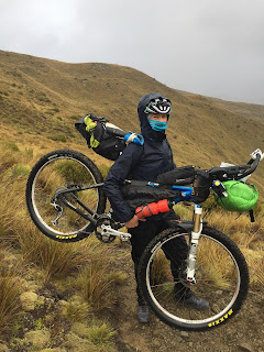
| My trusty 26" Scott hardtail MTB ready to roll! |
Brian Alder concocted the idea and created this route. He is an extreme  |
Completing the 9th lap
of my Everesting attempt
|
adventurer/bike-packing extraordinaire, who has a passion for testing the unknown. His concept was to keep it minimal, and to make the route tough enough to almost guarantee there would be a small percentage of rider attrition. He only accepted 50 entries, and carefully vetted who would be eligible to start. Thirty seven entrants made it to the start-line.
Serious preparation and training for this event began as my busy cow artificial insemination season wound down in mid-December. I used an "Everesting" attempt at the beginning of January to kick start my training (https://everesting.cc/ - 9 times riding up and down Mount Benger, 9000 metres of elevation gain in 18.5 hours). I raised $6000 for the local Breast Cancer fund.
 |
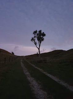
"Everesting" turn-around point
near the top of Mount Benger |
I also did a couple of local overnight bike-packing adventures. Other preparation included route research, and last minute purchases of essential gear i.e. Inreach Garmin device, and a torchmonster headlamp (a bright light for safe night travel). The Inreach Garmin device was my GPS navigation tool, PLB/SOS (Personal Locator Beacon) and Spot Tracker all in one. The Spot Tracker is GPS tracking tool that allows family, friends, followers, and dot-watchers (designated people who are watching to make sure you follow the route 24/7) to follow your progress.
My strategy for the race was to sleep 4-5 hours a night, and not blow myself to pieces by going too hard in the first few days. I have never done an adventure race before where you can go 24/7 until you finish, so this was going to be a new learning experience for me. First and foremost, the goal was to finish. I aimed to be finished within 7-10 days, as I had to be on deck for a volunteer driving job at the 8-day TransNZ enduro event on the 26th February.
When I signed up for this race, I knew there would be times when it was going to be tough. I also knew that those periods of pain would pass. One of the main reasons I applied to do this race, was to explore parts of New Zealand I wouldn’t otherwise get see if didn’t do the event. I wanted to embrace every moment of joy and pain, and find my physical limits.
 |
| Southward bound |
 |
| Cape Farewell sunrise |
A busy summer meant that February 14, valentines day, arrived fast. The only love I was about to encounter, was some tough love in the saddle. I was immersed in a moody Cape Farewell sunrise, along with 36 other anxious riders keen to get their wheels rolling. At 7am, on the dot, Brian shouted, "Let’s go".
 |
The lookout over Golden bay
at Martin Langley's memorial seat |
The first kilometre was a neutral zone, then it was race-game on. Funnily enough no one was keen to bolt. My plan for the first day was to aim for Murchison, which was 270 km into the route, with 3000 odd metres of elevation gain. The legs felt dangerously fresh. However, the climb up the Rameka track to Canaan Road soon took the sting out of my legs.
 |
| Top of Rameka Track |
Weirdly, a stop for a shuttle bus ride down the Takaka hill due to road works, was quite a welcome break. It meant I had a chance to fuel up and relax before settling into a meander down the West Motueka River Valley Road.
 |
| Catching the shuttle with Brian Alder |
Tapawera would be my last resupply stop until the Boyle River Education Centre at 385 km, where I had sent a food parcel two weeks prior. Every resupply stop had me asking myself, how much will I eat now? what do I feel like? how much food will I need to get me to my next resupply stop? I decided too much is better than too little. But then there is the problem of not having enough space on the bike to store it. I only ran short a couple times during the whole tour, and luckily I never found myself dangerously starving. I ate little and often, sometimes I ate a too much! My favourite trail food for the trip ended up being blueberries and squeezy yoghurt, brie cheese and dried fruit crackers, salted pea snaps, Macintosh’s lollies, gingernuts, chocolate liquorice logs, honey roasted nuts, toasted cheese and pineapple sandwiches, and either iced coffee or banana milkshake.
 |
| Milkshakes |

 |
| Leaving Kohatu |
At Kohatu, 170 km into the day, I was greeted by my sister Margy, and some enthusiastic friends who cheered me on and gave me the last hugs I would get until I reached the finish line. As I rode off into the sunset, there were no other riders in sight, and I felt alone for the first time. Although I was sad to say goodbye to my sister and friends, the sense of adventure kicked in, and it actually felt great. Sometimes when you ride with other people you feel pressure to keep up, or set a pace that you might not normally do.
The access to private farm land over Rainy River Road and Station Gully Road to Howard Valley included a few scenic climbs and a beautiful sunset. The agricultural smells, peace and quiet was sheer bliss. Then darkness drew upon me just before a steep, gnarly descent into Lake Rotoroa.
 |
| Howard Valley |
A few hours of meandering down Mangles Valley Road had me arriving into the lifeless town of Murchison around midnight. I decided to continue riding until I found somewhere sheltered to kip for a few hours. Another one of my aims for the trip was not to sleep outside if I could help it. I only had a lightweight bivvy bag, and I am not a fan of waking up covered in dew. A small, old wooden shed close to the road stuffed with empty super bags made for a stealth and comfy sleep.
At 3:30am I clambered out of the sack and began my daily ritual of popping a couple of CurraNZ capsules (to help with recovery from muscle fatigue), packing my gear and making sure I leave nothing behind. As I was about to set off into the morning darkness, Georgia Whitla (one of eight women who did the event) cruised past. This would be the last time I saw her. Although this was a race, it was never my intention to go out and win. However, it was fun to know I had created some race pressure which spurred her on to keep ahead of me.
As I cruised down the Matakitaki valley the three single speeders (aka, “The Monkeys”) who carried minimal gear, flew passed me like they were on a mission. This become a common theme most days. I learned later, that their strategy for the race was to reach their planned accommodation each night rather than roughing it. Therefore, riding with minimal gear meant they could travel faster.
Daybreak hit as I reached Maruia Saddle. It was a deja vu experience from when I rode the same saddle on the Tour Aotearoa (the length of NZ) in 2016, on an early, freezing cold morning. All I could think about was getting to Springs Junction for some hot food and what potentially could be my last caffeine fix for a few days. Although, there was a section through private dairy farm land to navigate first. I went a little off track into a patch of scrub, then bumped into another rider Liam Crozier, who came from a different direction. We conversed a little and then he rode off. Bike packing is like this, yo-yoing. You catch up with riders, then you either leave them behind, or vice versa.
 |
Tricky wire bridge
crossings! |
After an extremely disappointing coffee at Springs Junction, I headed over the Lewis Pass to the Boyle River Education Centre to pick up my parcel. I packed as much as I could onto my bike, and left the rest in a communal box that other people could take stuff from if they wanted. The next section of the route followed the Hope-Kiwi Track to Lake Sumner which had a lot of tree fall and bogs to negotiate. Brian Alder caught up with me during this section and we ended up travelling together to Deep Creek Hut which was on private land. The rules were strictly no staying in huts on private property, with the exception of a few places. In this case, we were allowed to camp under the pine trees outside the hut.
 |
| The start of the Hope-Kiwi Track |
 |
Tree fall on Hope-Kiwi Track
|
 |
| Wide open valley on route to Lake Sumner |
 |
| Lake Sumner |
This was the worst night sleep for the whole trip. We arrived at the camp site at around midnight, and I was cold, starving and exhausted. There were a few other riders already there, and sleeping. It was only manners to try and be quiet. At this point, all I wanted to do was eat and sleep straight away. I normally have everything organised for the next day before I lay down to rest. Instead, I decided to set the alarm for a quarter of an hour earlier than usual. I cooked up a Back Country Meal (BCM) and ate it whilst sitting in my sleeping bag with my head lamp attracting moths into my meal. I was so knackered that I did not care about the extra added protein of a few moths.
 |
Early, steep climb up Dampier Range
was a shock to the body!
|
I was also very cold, and lying on an uncomfortable downward slope of pine needles and cones, but I was too exhausted to want to sort it out. Finally, I decided to get up and put more clothes on. I had the most shocking wake-up call ever. I was in a comatose sleep and I hadn’t heard my alarm. Neither did I hear all the other people leaving at 4am. Brian threw a cone at me after he had tried to wake me up and I wasn’t responding. I got such a fright and woke up flailing my gear and phone everywhere. I was flustered, and annoyed about not hearing my alarm, and fumbling around in the pitch dark trying to find my torch or phone so that I could start getting organised. By the time I got my shit together Brian and I set off at 6:15am. Not a great way to start to the day. It could only improve, surely?

|
Looking back at the previous nights travel in the
dark down the Hurunui River from Lake Mason |
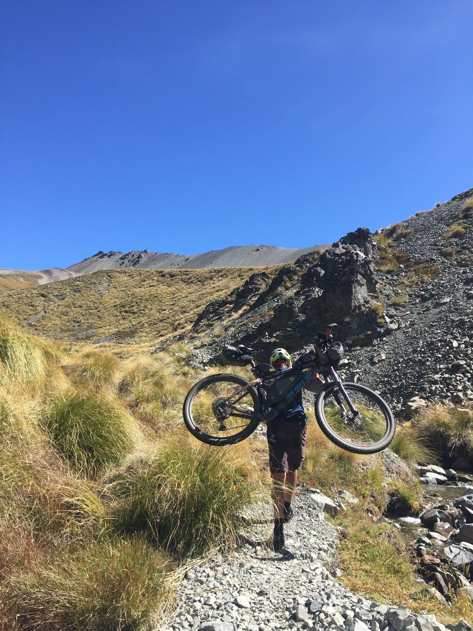
The next section up over the Dampier Range, was a bike carry through tussocks nearly as big as me, with the hill as steep as the side of a hens face! As we neared the tops at 1430m the fog rolled in, it started to drizzle, and blew a howling, bitterly-cold southerly. I ended up wearing every stitch of clothing I was carrying. I figured it was best to be warm and happy, rather than cold and miserable. As we dropped over the other side into Esk, the weather improved slightly. We were rewarded with amazing views, and a mint downhill section following animal tracks through tussock and beech forest down to Anderson Hut. We stopped for a quick refuel, removed some clothing, however, the southerly weather meant it was still extremely cold. Riding out through Mount White Station was a real privilege, and reminded me of the Pomahaka area at home with several pockets of manuka and beech stands. The mighty Waimakariri River also bought back many kayaking Coast to Coast memories.
 |
| Fog rolls in up Dampier Range |
 |
| Bitterly cold on top of Dampier Range |
 |
| Dampier Range tarn - No skinny dipping! |
 |
| And so the fun descent begins! |
 |
| Looking bit scruffy! |
 |
| Brian Alder at Anderson Hut |
 |
| The Esk Valley |
 |
| The EskValley |
After leaving a short main road section to begin the start of the Cass-Lagoon Saddle Track we ran into a random follower/trail pixie (a person who offers food to all riders who happen to be going past at the time). Note that the rules state that family and friends are not allowed to give food solely to you, and must offer it to other riders as well. This was one of the many highlights for me. Nina Stupples, and her dog Raewyn, were there to greet us with fresh fruit, hot miso soup, boiled eggs and chocolate brownie. The hot soup and boiled eggs was a perfect combination and heart warmer, and the four legged fur friend cuddles were an absolute treat.
I set off from here really happy, and was looking forward to the next section. I had done this section as a practice-run earlier in January, so knew it well enough. It is mostly a hike-a-bike section negotiating a rocky braided river to begin with, then a gnarly beech forest climb to Cass Hut. Originally, I would have liked to reached the Hamilton Hut that day. However, I was still hanging out with Brian and Liam who admitted they were exhausted. So we all decided that it was a good idea to do the down-hill section to Hamilton Hut (which we all knew was a fun descent) after some sleep. The Hut slept 3 people, Liam lit the fire, we ate, and I joked about carrying my hand warmers packs, that at the time, I thought wouldn’t have been necessary.
For those who are interested in statistics, this day was the shortest distance travelled of the whole race: 85km, 2124m – So yes, there was a whole lot of hike-a-biking involved. Although, for some reason it felt more on the days to come.
After a warm couple of hours kip, we set off at 4am for what was a fun descent off the Cass saddle. Liam is an extremely good technical rider and rode his bike like it was a down-hill enduro event! As day broke and we exited the beech forest, and were greeted by Jack Frost as we rolled down the valley to Hamilton Hut. As it turned out, Hamilton Hut (sleeps 20) was exploding with people and we wouldn’t have got a bed there anyway. A good decision made the previous night!
 |
| Sunrise and chill factor! |
 |
| Eat for warmth! |
We set off into the frost down the Harper River which involved several icy cold crossings. The Monkeys overtook us again. The sunrise and scenery was stunning, however, there wasn’t too much banter going on. Everyone was suffering frozen, numb feet and hands, dripping noses, and icicles hanging of any hair that was exposed. I suddenly had the urge to use my hand warmers. Oh my goodness, how good were they? My skiting about it did not get any responses from Liam or Brian. I think their voice boxes had frozen! This day went down in history in the Methven district, as the coldest temperature recorded in February ever.
 |
| Puffy morning eyes |
 |
| A bitterly cold, freezing Harper Valley |
Once we hit Lake Coleridge Road which led to the end of the Rakaia Gorge, the sun came out and slowly thawed us out. I was dreaming of what I wanted to eat in Methven, the first real sit-down meal |
Drive-chain service - Well worth
the $10 spent! |
since I left Cape Farewell. Methven was the half-way point and the only place there was a bike shop on the route. I felt good, so I high tailed it into Methven. I spent a fortune at Café 131. While I was there, and I had the mechanic at Big Al’s bike shop next door check my bike over, and clean the drive chain. I made a list of what supplies I would need for the next part of the journey, and had two cheese and pineapple toasties made to go. I picked my bike up. It was running good before I took it in, but it was running even sweeter with a little love. Well worth the money and peace of mind. Consequently, my 2008, 26” Scott Scale hardtail mountain bike never missed a beat the whole trip! I know a few people marvelled at my old trusty steed at the beginning of the trip!
I grabbed some groceries, and once again I joined the company of Brian to pedal across the long, mind-numbing straights of the Canterbury Plains toward Mesopotamia Station. One thing I’ve discovered about bike packing and stopping for sit down meal, is that it is too tempting to eat too much. Yes, I ate too much!
 |
| Rangitata Valley |
 |
| Riding out the Rakaia Gorge |
Riding into Mesopotamia station at dusk was absolutely gorgeous, and I was excited to explore a new part of New Zealand I have never been to before. The sunset and wild life running around gave me a pure sense of peace and freedom.
 |
Snack stop up
Rangitata Valley
|
 |
| Sun setting on Rangitata Valley |
It was an hour away from darkness, and Brian and I had to decide whether we should embark on getting to the only hut we were allowed to stay in on this private property, or whether we camped up before entering the station. It had been a long day since 3:30am at the Cass Saddle Hut, but I was keen to keep trudging on. We arrived at Felt Hut, which was a 300m drop in elevation off the route, at around 1:30am. At the time, this was disheartening to know the next day would start with an uphill push-bike. However, the hut was empty, so we took our bikes into the hut, made ourselves at home, cooked up a feed, and had a luxurious sleep-in until 6am.
 |
| Felt Hut |
 |
First push of the day, to
regain the 300 metres
elevation lost the
previous night! |
Day 5: The day of the “Stag Saddle” – What a fabulous sunrise yet again, and an absolute stunner of a day to be crossing the Bullock Bow Saddle (1692m) and Stag Saddle (1925m). You wouldn’t have wanted it any other way!
 |
| Another magic sunrise climbing up to Bullock Bow Saddle |
 |
| Bullock Bow Saddle - North facing |
 |
| Bullock Bow Saddle |
 |
| Brian setting off the top of Bullock Bow saddle in the distance |
Poor weather would have made this section impassable. I was blown away by the scenery after crossing the Bullock Bow Saddle. It just kept getting better!
 |
| Stunning scenery |
 |
| Shall I? |
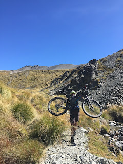
I stopped at a tarn, and was contemplating a skinny dip when Liam rocked up. After deciding it would take too much time, I chickened out, and we carried onto Royal Hut for a good snack before heading up over Stag Saddle. When I saw Brian getting out his shoulder strap rig for carrying his bike, it really hit home that we were in for a serious hike-a-bike. He disappeared into the distance.  |
| DOC Royal Hut on the Te Araroa Trail |
 |
Brian's shoulder straps and
bike carrying method
|
 |
Brian setting off for
Stag Saddle, and leaving me
for dust! |
 |
| Is that Stag Saddle up there? |
 |
| Clambering up to Stag Saddle |
 |
| Pointing to the top - I hope! |
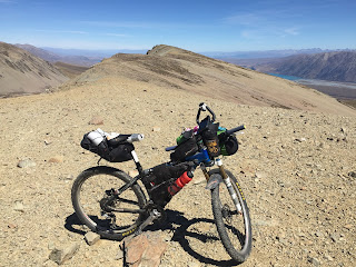
I threw my wee Scotty (bike) on the shoulder, and off I set. It was a good slog for probably 3-4 hours. All the bike carrying training I did prior to this race, paid off for sure. The daily occurrence, happened again, the Monkeys overtook me half way up Stag Saddle. I was jealous of their light-load set-up. I had to make small goals which involved getting to the next tussock or rock only 5-10 metres away from me, or alternatively, I would count 20 steps. Then I would put my bike down, count 10 breaths, admire the scenery, then do it all again over and over until I reached the top. It was a battle, and I don’t actually know how I did it. The reward and vistas of Aoraki/Mount Cook, Southern Alps and Lake Tekapo at the saddle was worth every bit of sweat, blood and mental games.  |
| Finally, the relief and joy to be at Stag Saddle was unsurpassed! |
It was a boulder-hopping scramble for the next few kilometres before you could actually get to mount your bike, and ride the mint downhill section down the Two Thumb Range heading towards Tekapo.
 |
| A boulder scramble! |
 |
| Views of Lake Tekapo |
Just when I thought I could see the road, the route sent me into the back country again for some more bike carrying and rough riding. This is when I began to feel demoralised, because I wasn’t sure I had the strength to lift my fully loaded bike anymore. I grunted and groaned, and finally I sat with Liam who was fixing multiple flat tyres, at the top of a hill. He assured me it was the last bike carry of the day. He had double flatted coming down the Two Thumb Range descent because he admitted to having too much fun, and rode too hard. When you are riding with a fully loaded bike you need to ride the bike, to survive it. I felt sorry for him, and would have loved to have been able to help him. Unfortunately, the strict rules stated: no helping each other out (unless of course it was life threatening). His attitude towards his predicament was a real credit to him. He was positive, and he got himself into Tekapo on two shredded tyres, where he awaited two new tyres to be delivered before continuing his journey.
 |
| Views of Aoraki/Mount Cook |
 |
The start of a mint rocky descent
down the Two Thumb Range |
As it turned out, one thing I was grateful for, was buying a really good pair of walking/Giro mountain bike shoes in December. With the amount of hiking involved and rough terrain, many riders had their shoes disintegrate. Luckily mine held together.
I arrived in Tekapo at 8pm with half an hour to spare before the supermarket and fish & chip shop closed. I did a mad rush round the supermarket for supplies that would get me to Otematata, while my fish & chips were cooking, and my power bank was charging. After reuniting with Brian, eating, restocking and packing my bike, I decided to make use of the warm evening, and tail wind to ride further on down the Tekapo Canal.
 |
| Magical colours of the sun setting on the canal |
 |
| Beaut evening for a pootle down the Tekapo Canal |
The ride down the canal was incredibly refreshing and spiritual as the sun went down over Aoraki/Mount Cook. That night I camped under some pine trees at Lake Pukaki. This time I made sure I had flat spot on a nice bed of pine needles to lie on.
I had great few hours kip and felt really good the next morning. The blue berries, yoghurt and gingernuts were a treat for breakfast. The ride down the Pukaki River track was a bum shuddering experience.
Another scorching day was on the horizon and Aoraki/Mount Cook was towering in all its radiant glory. I said to Brian, “I reckon we will make it to Oturehua today”. His reply, “we might”!
 |
| Scorching day on the horizon! |
 |
Another brisk start to the day!
Aoraki/Mount Cook in the background |
Not long after that statement, I pulled up alongside Brian who was stopped, and straddled over his bike. He said he had just stopped for a cry. He had been having trouble with his gears since Methven, and they had finally stopped shifting. They were stuck in his highest gear. I totally understood his fate. Imagine the organiser of his own event having to pull out because of gear failure. That would definitely make me want to cry. I thought I was going to get to drop him, however, he asked me stay for my moral support. I stayed with him, and thankfully he came up with a solution to the problem that allowed him to continue. I learned a valuable mechanical trick from his bad luck. Depending on the steepness of the terrain, he would change his gears to a suitable range by adjusting the cable each time. By the end of the trip he had this down to a swift 30 second operation.
 |
| Benmore Dam |
The ride through Black Forest station over to Lake Benmore Dam was spectacular. I was looking forward to lunch in Otematata. I always know I’m close to home when I can buy a Jimmy’s Pie, what a treat! As we rode through the start of Otematata Station we bumped into the owner, Pip Richards, who was rushing over to greet and open the gate for us. I assured her, that stopping to open a gate is often a welcome respite for the weary bike-packer. It turned out, I knew her from the days when we trained together for the Coast to Coast back in 2007. We had a lovely short chat, and she informed us that the push up the hill would be worth it for the ride down into Long Gully and the Otematata River.  |
| The taste of home! |
It was a sweltering 40 degrees amongst the schist rocks that were radiating off intense heat, as we followed along the Otematata River. At around 3:30 pm I said to Brian, “I am cooking, and the next chance I get, I am going to swim”. There was a perfect swimming hole in Clear Stream, next to the Cableway Huts. As we were enjoying a refreshing skinny dip, what do you know, along come the Monkeys. They joined our swimming party. It was like a group of lazing crocodiles (rippling with muscles) basking in the sun. After the soak, we all lounged around fuelling up, and mentally preparing ourselves for the next big hill climb/push up Chimney Creek, and over to the Hawkdun Range. Once again, the Monkeys disappeared into the distance on a mission to their Oturehua accommodation.
 |
| Clear Stream swim |
 |
| The Monkeys lazing like crocs |
 |
| Three generations of huts at Cableway Huts |
 |
Bikes parked while we cooled down!
|
 |
| Pushing up out of Chimney Creek |
As the sun went down, funnily enough, we were walking up Walking Spur, and we crested the top of the Hawkdun Range at 1643m in the dark. There wasn’t a breath of wind. It was even warm at 10:30 pm. I couldn’t believe our luck with the weather Gods, and I contemplated how different it could have been in foggy or cold weather conditions. This section of the route is exposed for a long period of time, therefore, in poor weather conditions, carrying emergency shelter, or staying in Otematata would have been the only safe options. The descent off the top would have been spectacular on dusk. Instead, we negotiated the very steep, sharp and rocky descent in the dark. We had to stop several times to let the brakes cool down and give our numb, white fingered hands a rest from hanging on tight. Oturehua was in our sights, yet still another 20km away.
 |
| The sun setting on the Hawkdun Range |
 |
| Walking up Walking Spur |
It was freezing cold down on the flats of the Ida Valley. I had a pre-sent parcel waiting for me at the Oturehua Store Postal Centre, that I had arranged to be left out knowing I wouldn’t make it there during opening hours. In my parcel was fresh pair of bike pants, food that I didn’t feel like, and lube for my chain. I quickly sorted my gear, and carried on the Rail Trail for a few kilometres to a shelter I knew would be a good place to kip for a few hours (provided no one else had the same idea!). I put all my clothes on, crawled into my sleeping bag which lay on a two-plank seat. I also sleep on a light weight three quarter, blow up mattress, which in bike-packing terms is considered luxurious. As I was falling to sleep I heard Brian say, “my planks are uneven”. He tossed, turned, and groaned. I was too tired to care or feel sorry for him. In the morning the first thing he did, was check where I had slept. He looked so disappointed, and I have to admit, I had a quiet chuckle to myself for scoring the best possie for a bed!
 |
Fully cladded before setting off
into the Ida Valley chill |
 |
| Ida Valley fog |
From this point, there was 315km with 3300m elevation gain left to reach the finish line at Slope Point. I was in my home territory now, and I had always planned to ride to the finish from here with no more stops for sleeping. I also didn’t want to go through another night of waking up feeling like crap, so not stopping seemed like a great idea. At 5:30am we set off, and it was so damn cold in the Ida Valley that I wore all my clothes. The fog lifted and the sun came out, so we stopped at the old Moa Creek pub where we refuelled and de-clothed.
 |
| Old Moa Creek Hotel |
 |
| The sun coming out to thaw us out! |
As we began the start of the climb to Poolburn Reservoir, I was feeling upbeat and excited about the prospect of finishing before the 7 days was up. Then without warning, my left leg, adductor muscle started to twinge with excruciating pain. I couldn’t work out why this happened, and still don’t really know why it did. Brian said he had experienced the same thing before, and told me to chuck some more pain relief on board, ride it out, and that you can also stop to stretch it out. I took his advice, however, the pain persisted. Even worse, the right adductor muscle started to twinge as well. Once again, the Monkeys caught us and rode with us for a while, then cruised off.
 |
| Lake Onslow in the distance |
It was a long haul through the Serpentine and out past Lake Onslow. I also knew there was another 1000 metres of elevation gain between Mount Teviot, Avenal Station and Beaumont Station before descending down to Beaumont. I was nearly out of food, and I had been dreaming about trail pixies meeting me at Lake Onslow. But there were no pixies to be seen. I was disappointed and sadly, I walked up the hill to Mount Teviot, the last highest point at 977m, of the route. Once I received cell phone reception at Avenal Station, I rang the Beaumont pub and ordered a pizza. I was probably still two hours away, but at least that spurred me on to get there quicker.
At 6pm, I was about to head out onto the main road, and over the Beaumont bridge to the pub. There was my truck parked, with my dear mother and sister Trish, who had been waiting there since lunch time. Trish asked me why it took me so long to get there from when she last checked the Spot Tracker. Bless her, if only she knew! They had been giving food to other riders, and offered me some food as well. I was exhausted and focussed on the pizza that was waiting for me at the pub. I had a quick catch up with them, and made a rough plan for Trish to meet me at Slope Point, which was still another 175 km. I ate pizza and Panadol, and left the pub feeling bad that I didn’t stop to chat for longer, but I was now on a mission for the finish line.
I caught Brian again in Lawrence. I grabbed an iced coffee and a muffin and said to Brian, “I am not stopping now until I get to Slope Point”. He had the same idea. So we set off again, and it wasn’t long before we turned to go up Breakneck Road, aptly named! I found myself walking up this long, steep tar seal section of road, which turned into a terrible chunky gravel road. It was undulating to the degree you didn’t get enough down-hill momentum to get you up the next rise. At this point, I was cursing Geoff Blance for choosing this part of the TTW route (sorry Geoff – I’m sure it would have been a nicer ride in daylight).
The adductor muscle pain I was suffering from caused me to go slower, and I was struggling to focus. We stopped at the Clydevale garage around midnight, and I said to Brian “my mind is willing, but my body isn’t”. He looked at me sternly, and replied, “You should listen to what you just said, and do something about that”. I had found my physical limit. I reluctantly took his advice, nipped into the implement shed beside the garage, and pulled out my bed roll, and ate more drugs. I set the alarm for an hour. When the alarm went off, I swear I woke up fresh as a daisy, rearing to go, with no pain in my legs. It crossed my mind that maybe one hour kips are better than longer four hour sleeps.
 |
| A cool foggy morning! |
It was peaceful riding the back roads in the dark early hours of the morning to Clinton, where I rang Trish to let her know that I was hoping to make it to Slope Point before 7am. I had worked out I needed to average 30km/hr. What was I thinking? I totally underestimated the last part of the route, or how long it would take me. Daylight broke and a stunning finale sunrise greeted me as I was riding down the Slopedown Road.
 |
| Slopedown Road sunrise |
7am rolled by, and I realised that I had been far too ambitious and totally miscalculated my physical ability to get to the finish when I said I would. I was annoyed at myself and felt bad that I had dragged my sister out of her bed too early to drive my truck down to meet me. Then I told myself to accept it, enjoy the moment, and know that each pedal stroke is a stroke closer to the finish.
 |
Tahakopa Road - I was imaging seeing the sea,
only to see a sea of cloud |
As I came into Waikawa I saw that I had another 20 km to go. There was a strong head wind. I wanted no one else to pass me in these last few kilometres to the finish. Suddenly I felt like I was cross country racing and going as hard as I could. My phone started to go crazy as I was receiving continuous text messages of support and congratulations from friends and family. I refrained from reading them until I finished. The last climb before dropping down into Slope Point lighthouse was brutal. I kept looking back over my shoulder to make sure no one was coming. Finally, over the brow I could see my truck in the car park, my sister, the lighthouse, and the ocean. I shouted out a sigh of relief and overwhelming joy. Trish welcomed me with loving arms, opened the gate to the lighthouse track for me which was another 1km further on, and videoed my grand entrance to share with all my family and friends. Brian had finished approximately 50 minutes earlier, and was at the lighthouse soaking up the moment. Trish took photos, pulled my shoes and socks off as I lay on the ground. The feeling of accomplishment, and the relief to be stopped was indescribable. I was quite chuffed to learn I had beaten the Monkeys to the finish line.
 |
| Sheer bliss to be finished! |
 |
| Brian and I taking in the finishing moment |
This is undoubtably the hardest challenge I have encountered. I learned how the power of the mind can will your body to go beyond the threshold into its extreme limits. I found my physical limit, and I am proud of my achievement. I enjoyed every moment of this race, including the people I met, the stunning scenery along the way, sunsets, sunrises, and even the pain. The back country hike-a-bike experience was not for the faint hearted, but worth every bit of effort. Just for the record, 37 riders started (8 of which were females – and we all finished), and 32 finished.
I am stoked with my finish time. I finished in 7 days, 3 hours, 44 minutes. I was 2nd female, and 7th overall.
 |
| First and foremost - Finishing :-) |
Acknowledgments:
There is a few people I would like to acknowledge and thank for their support, both before, during and afterwards. You made it possible for me to make it to the start line, and gave me the strength to believe in myself:
 |
Relaxing with family at Wharariki Beach
the day before TTW started |
My sister Margy, Stu and family: I cannot thank you enough for your support in the week leading up to the event. Your hospitality, company and keeping me both calm and suitably excited prior to the start was truly humbling.
- To all my family and friends who followed the spot tracker/me the whole way, and sent messages of support. It certainly spurred me to keep trucking during the times when I was feeling physical pain and tiredness.
- To the school kids at St Peter Chanel in Motueka, my new fan club: thank you for being so enthusiastic and interactive when I came to visit your school, and chat to you lovely kids about the adventure I was due to embark on. Knowing you were watching my progress each day was an excellent motivator many times on my journey.
- Colin and Jill: My good North Island friends who made a special trip out to Kohatu on the first day to cheer me on, and see me off into the sunset. Thank you for your wonderful admiration and support.
 |
Trish - Best support crew!
|
My other fabulous sister Trish, who met me at the finish line (and has done on countless occasions!) I felt cruel waking Trish at 4am with a phone call from Clinton to say I would see her at Slope Point at 7am, suggesting that she should get out of bed and get down there to meet me. Only to realise later that it would take me quite a bit longer than I anticipated to get there. I rolled in at 10:30am. Sorry Trish. You are so very patient, and as per usual, you were there to greet my stinky, filthy old-self with your best welcoming-home hug. I appreciate all you do for me. You were super organised, had food ready for me, clean clothes, most importantly, SOAP and a towel for me. You truly are a gem!
- To Lester Cochrone who looked after my two best four-legged fur friends, Gus and Bee, while I was away for nearly a month. It is so good to know my pooches are being loved and well looked after while I am away adventuring. I cannot thank you enough.
- Racers Edge Wanaka, thank you for your continued support! You keep me fuelled, clothed and my gear running smoothly thanks to the great mechanics and staff. I really appreciate your speedy and efficient work.
 |
I think this kit is done for!
|
 |
CurraNZ product - I swear by it!
|
CurraNZ - I have been using this product religiously for a couple of years now. On epic adventures such as this, I bump up my daily dose. It helps me recover quicker and keeps me powering on with the active lifestyle I lead. I wouldn't want to live without it!
- The weather Gods – what an amazing spell of weather we had for most of the race! If weather conditions had been poor, this race would be a whole lot more challenging, and potentially dangerous for those who do not respect back country and high altitude environments.
- Last, but not least, Brian Adler: Thank you for dreaming up a truly epic and tough route. Thank you for putting in a huge amount of planning, effort, and liaising with private land owners to make this event possible. You should be super proud of yourself:
a) for riding and finishing the inaugural event, and
b) for pushing every rider who rode the TTW to their limits
That is why we turned up, right? Also, thanks for listening to my stories, and sharing some of your adventure stories with me, while we travelled such a long way together during this event. It was an honour and a pleasure to hang out with you, and get to know you a little.


No comments:
Post a Comment